Lab three required aerial photo interpretation and delineation of polygons based on selection criteria.
 |
| Image 1: This image is a JPEG version of the original .tif file used as the source data. |
The image was supplied as a TIF file. Using ArcCatalog, I was able to create a new shapefile and use the create features tool to digitize a variety of land use and land cover types, based on my understanding of photo interpretation so far.
A cursory examination suggests that there is a large tidal zone dominating the left side of the image. This is likely a tidal zone due to the presence of tidal flats, and the sinuous quality of the channels.
There is a large road running through the middle right which appears to be a center of commercial activity. This proximity influenced many of my categorizations of the parcels as "commercial services.
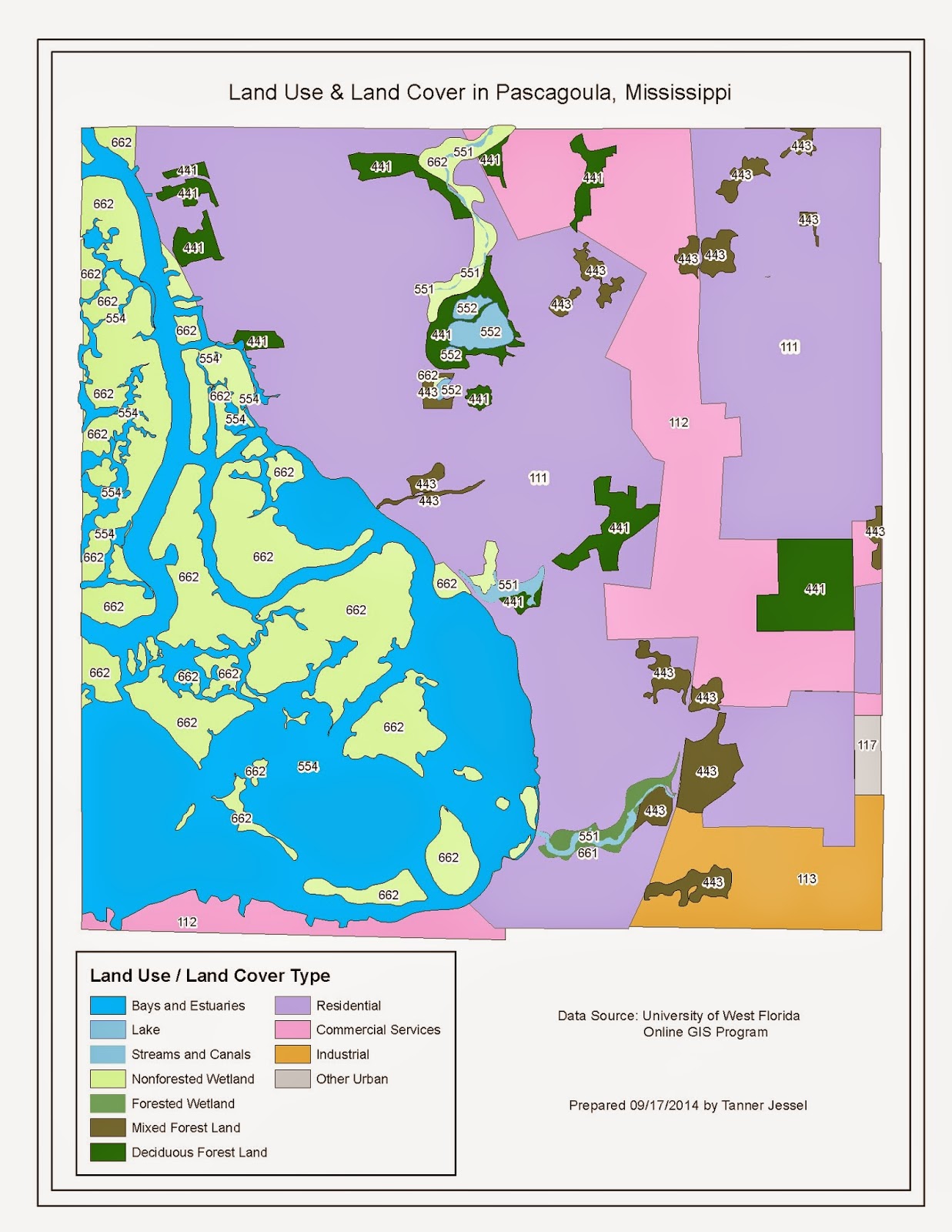 |
| Map 1: Resulting graphic communicating my land cover and land use classifications. |
The final map included a neatline. I would have preferred to somehow "clip" the edges of the shapefile to the graph.
I felt confident in characterizing the following land uses and land covers:
- Industrial
- Residential
- Commercial Services
- Other Urban
- Streams and Canals
- Lake
- Bays and Estuaries
- Deciduous Forest Land
- Mixed Forest Land
- Nonforested Wetland
- Forested Wetland
The codes, description, features, and rationale for each of these areas is described in the table that follows.
|
Code
|
Description
|
Features
|
Decision Points
|
|
113
|
Industrial
|
Industrial. Large facilities, vehicles
|
Proximity away from residences, other commercial areas,
equipment
|
|
111
|
Residential
|
Single Family Homes, Driveways, Lawns, School
|
Proximity to main throroughfare, commercial area, waterways
|
|
112
|
Commercial Services
|
Business
|
Proximity to main thoroughfare, parking lots, air conditioners
|
|
117
|
Other Urban
|
Cemetery
|
Headstones indicate cemetery
|
|
551
|
Streams and Canals
|
Linear waterway
|
Apart from main estuarine environment
|
|
552
|
Lake
|
Circular water feature
|
Dark tone, very fine texture, isolated
|
|
554
|
Bays and Estuaries
|
Large area, sinuous form, tidal areas
|
Dark tone, fine texture, to boundary of tidal areas.
|
|
441
|
Deciduous Forest Land
|
Trees of uniform consistency
|
Very coarse texture, homogenous, uniform color
|
|
443
|
Mixed Forest Land
|
Trees of varied consitency
|
Very coarse texture,
heterogenous, varied color
|
|
662
|
Nonforested Wetland
|
Vegetation and tidal flats of varied color
|
Fine texture, proximity to water, proximity to estuary
|
|
661
|
Forested Wetland
|
Shrubs of varied color
|
Coarse textture, proximity to water, estuary, river
|